
An extract from the Wikipedia to introduce the Catharism to start with:
Catharism was a Christian dualist movement that thrived in […] southern France, between the 12th and 14th centuries. Cathar beliefs varied between communities, because Catharism was initially taught by ascetic priests, who had set few guidelines. The Catholic Church denounced its practices and dismissed it as “the Church of Satan”.
[…] Though the term “Cathar” has been used for centuries to identify the movement, whether the movement identified itself with this name is debatable. In Cathar texts, the terms “Good Men” (Bons Hommes) or “Good Christians” are the common terms of self-identification. The idea of two Gods or principles, one being good and the other evil, was central to Cathar beliefs. The good God was the God of the New Testament and the creator of the spiritual realm, contrasted with the evil Old Testament God—the creator of the physical world whom many Cathars, and particularly their persecutors, identified as Satan. All visible matter, including the human body, was created by this evil god; it was therefore tainted with sin. This was the antithesis to the monotheistic Catholic Church, whose fundamental principle was that there was only one God, who created all things visible and invisible. Cathars thought human spirits were the genderless spirits of angels trapped within the physical creation of the evil god, cursed to be reincarnated until the Cathar faithful achieved salvation through a ritual called the consolamentum.
A tourism highlight of the region, the French Sud-Ouest, is the visit to one or several of the many Cathar castles spread in it.

“Cathares air ways”, Info Pilote magazine.
Years ago, a colleague (Asier) shared with me an extract of the French Aviation Federation (FFA) magazine, Info-Pilote, with a proposed route to fly over some of the Cathar castles in the region. Ever since, this has been an excursion in the to-do list.
A few days ago we did it.
I booked some weeks ago a plane of the aeroclub for 3 hours for the morning of Sunday 17th. We were lucky enough to have an incredibly sunny, calm and clear morning in the mid of cloudy and rainy weeks. Thus, we went to the aeroclub and at 9am we started preparing the plane, checking last-minute weather reports, NOTAMs, restricted zones, printing a missing aerodrome chart, refueling the plane… the series of procedures that make general aviation take always longer time spans than you think.
At 9:50am I started the engine.
“DR400 avec 4 personnes abord au parking ACAT, avec l’information Alfa, pour un vol de navigation autour des chateaux cathares, pour rouler au point d’arret de la piste 33…”
What followed were 2 hours of a wonderful flight.

Navigation log.
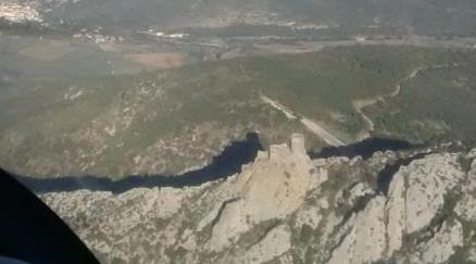
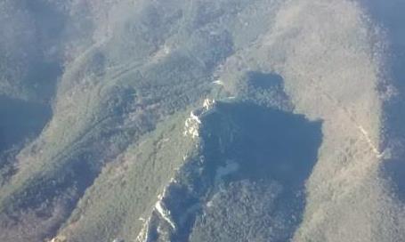
The route, as calculated while I planned the navigation the night before, extended for over 160 nautical miles (about 300 km). We flew over the following Cathar castles: Saissac, Lastours, Carcassone, Termes, Queribus, Peyrepertuse, Puylaurens, Puivert and Montsegur.
Each of those castles definitely deserves a walk-in visit. But, yep, among the many cool things aviation can offer on the spot walk-in visits are not among them. I had visited before the castles of Carcassonne and Montsegur, I now have on the to-be-visited list some others, though most of them are not easy at all to access.
I will be brief in text and generous in pictures (1).

Saissac.

Lastours.

Carcassonne.

Termes.
Queribus.

Peyrepertuse.
Puylaurens.

Puivert.

Montsegur.

Pyrenees.

Cockpit.

Andrea’s feet.
—
(1) In fact, the generosity and credit go to both Luca and Asier who were the ones taking the pictures.


