Tag Archives: Lasbordes

ACAT aviation rally (rallye aérien) 2018

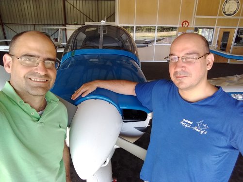
Last June 23rd, together with my friend Asier, we took part for the first time in an aviation rally (rallye aérien) organised by my aero-club, ACAT.

ACAT_Collage

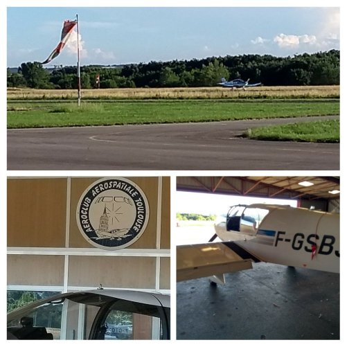
For starters, an aviation rally, following (more or less closely) the rules of the Aviation French Federation (FFA), is not like the sport cars’ rallies that we may be used to see. It is not about who is the fastest in a given circuit. It is rather about precision, and the purpose of organizing such rallies is to improve as pilots and increase the safety of flight, along with the competition side of it.

The rally in itself included the following parts:

  • A theoretical part.
  • An observation part
  • A navigation part.

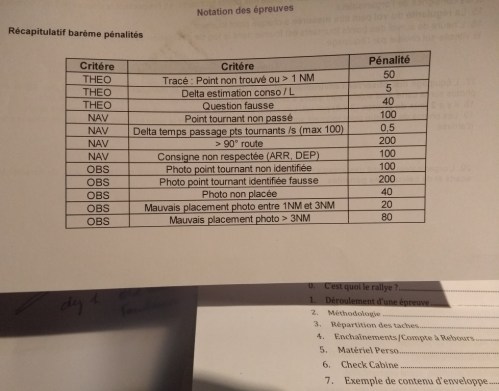
In order to rank the teams, a series of penalties are introduced in each of the parts, as described below:

Rally_ACAT_penalties

In order to discover the route of the flights, even if not subject to penalties, the different teams received a questionnaire. By correctly guessing the answers to the questions we would be able to find the route that we had to fly. For this we had a map, a ruler and pens. From that moment the flight preparation started.

We made two flights of about 1h20’ each. In each of the flights, a part of it would be the subject of the competition, defined by a “starting” and “finishing” points that we had to closely over fly. In between those points a few turns had to be made. We had to estimate at what time we would fly over each of the points with a precision of plus or minus 15 seconds. A greater deviation than that was penalized.

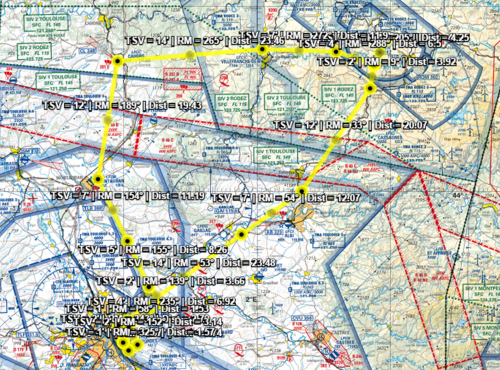
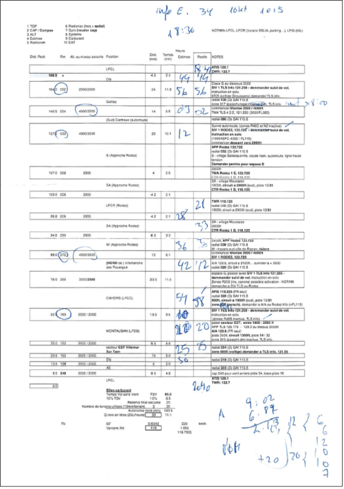
To correctly track the route followed and measure the time in which we flew above each of the points, we carried 2 GPS recording devices provided by the organization. With them, the organization was able to print the track of the flights as below.

Rally_ACAT_trajectory

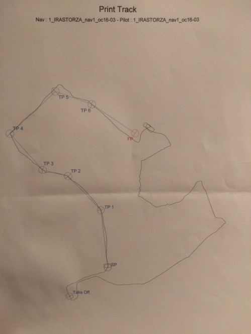
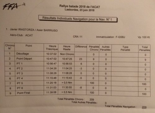
The image above corresponds to the first of the two flights. In the image you can see that we missed the Final Point, in red. But in the table below you can see how we passed the different turning points. We over flew the starting point (10 minutes after take off) 23 seconds behind schedule, which carried a 9 points penalty. The following turning point (PT1) was passed in 6 seconds above schedule…

Rally_ACAT_score

Along each of the flights we had to spot on the ground a series of images (16 per flight). For that we had some papers with small photographs taken in advance by the rally organization. When we saw an image, we had to identify where we had seen it in the map we had been given. The photographs for each of the flights were not in order, so we had to pay attention to see them. The more you saw, the less you were penalized. However, if you placed the landmarks corresponding to the photographs in wrong locations in your map, you were penalized as well.

Rally_ACAT_photos

Before the flights we had to estimate the overall fuel consumption of the aircraft for the two flights. After the flight we refueled to see how good or bad our estimate had been. In our case we had estimated 69 liters and needed 67. Not bad. But those 2 liters of deviation, carried the corresponding penalty.

As part of the theoretical side of the rally, we also completed a multiple choice questionnaire, similar to the PPL exam but shorter.

The experience was great. We had much fun and even if we did not place well in the rally, we learn quite a bit out of it: (1) to select a slower target speed to allow for wind variations and then set your speed to the targeted one instead of compensating at turning points, (2) to better prepare the reaching of the Starting Point of the circuit, (3) the lower fuel consumption to be employed when flying in with a lighter take-off weight.

I guess we will take part in more aviation rallies in the future.

Rally_ACAT_selfie

1 Comment

Filed under Aerospace & Defence

My grand navigation solo

When talking about flying lessons and my progress (or the lack of it :-)) I am often posed the following question or comment: “but if you are taking lessons… then you always fly with an instructor, right?”

The answer is no. Unlike car driving lessons, part of the requirements to become a private pilot is to have completed a given amount of flying hours having flown solo (i.e. without instructor), part of them “navigation” flying hours (1).

Flight Crew Licence formation requirements.

Flight Crew Licence formation requirements.

The first flight solo is typically a marking moment in the flying life of a pilot. See here a post with my experience then. The first flights solo are typically around your home aerodrome, where you are used to all geographical accidents, the aerodrome circuit, radio frequencies and you may feel less stressed. A friendly scenario where to push the bird to fly.

There are many other marking moments in the flying life of a student pilot: the first take off or landing that you do at the controls, or the first navigation solo. The word navigation is used to describe flights going from one aerodrome to another, hence some navigation skills are required and employed to reach the destination.

Then, another big marking moment is what in France is called the “Grande Nav solo”. As its name points out, it is a solo flight implying navigation, but then a big one, a rather long flight. Specifically, as required by the FCL 1.125 (b) (1) “done au moins un vol en campagne d’au moins 270 kilometres (150NM), au course duquel deux aterrisages complets doivent etre effectues sur deux aerodromes differents de celui de depart” (see requirements above).

I completed such grande nav solo flight back on July 23rd. I had been after it for months, trying to find a slot with good meteorological conditions and having accumulated some flight hours in the prior weeks to feel at ease. It was big moment that I wanted to share here.

For that navigation we selected the route Toulouse Lasbordes – Rodez (2) – Cahors and back to Lasbordes. The route had over 160 nautical miles (over 300 kilometres) and would take me over 2 hours, including the two complete landings. You can see below the route in a screenshot from the 1/500.000 aeronautical chart available at the website carte aero fr.(3)

Route planned for my grand navigation solo.

Route planned for my grand navigation solo.

The experience during the flight.

The flight went remarkably well, even if I started a bit pressured because of the time.

I arrived at the aerodrome at about 18:00. With the flight preparation, finding out last information about weather, points of contact for special zones, pre-flight check list, etc., I only managed to start the engine at 18:36 local time. At that point I started to have some doubts of whether if anything went wrong I might not be able to return back after the complete flight… would I have to shorten it? I decided to take a look at the timing at Rodez parking.

After the take off, and en-route to Rodez, right after quitting Lasbordes’ radio, I passed with Toulouse Info and demanded a flight tracking, which is reassuring at the beginning. I couldn’t start climbing up to 4,000ft right after flying over Gaillac as there was some Airbus traffic coming from Blagnac. Reaching Camaux, close to Albi, I had to turn left (033) and then I could start the climb.

The week before I had got lost while navigating towards Rodez (I was then with my instructor, and we found ourselves with the help of a GPS). Not this time. I paid much detail to the navigation, finding the villages that marked the different way points of the approach to Rodez, and cross-checking with the tower that I was indeed at those points.

Curiously enough, when I was at the parking in Rodez there was a helicopter coming in, which followed the same descent path, runway, taxi way, etc., as if it was an airplane.

At the parking, I quickly made the numbers and thought I would have enough margin to complete the whole flight so I decided to go.

On the way to Cahors I continued being followed by Rodez Info (same controller than Rodez tower). When I mentioned that I was quitting to pass with Toulouse Info frequency he noted that I could continue with him all the way to Cahors, so I did. Having the sun setting in front of me and not wearing sun glasses that afternoon it was difficult to locate the terrain. I was seeing some cleared land about 10nm ahead, thus, I again asked the controller. He confirmed that it was Cahors aerodrome and that the distance was 8nm. Good. Second leg almost done.

I passed to Cahors frequency. As there was no controller it operated only for communication between airplanes… and parachute jumpers, as there were many jumping at that moment. The pilot of the plane from which they jumped proved quite helpful there. Even if I had studied the aerodrome chart, he provided all kind of explanations via the radio at my arrival:

“as there is parachuting activity, don’t fly over the vertical, integrate yourself directly into the circuit. There are no more airplanes at the moment, report in base leg (the circuit is a right hand for runway 31, the one in service). There are two exits to the runway, take the second one as in the first one there is a plane waiting for departure: me…”.

While parked at the tarmac, I drank some water and listened to some message for me. They offered to sign something for me. I wasn’t not understanding it fully. What did I need to get signed? Nothing. So I asked them about that. Apparently they offered to sign some paper as a souvenir of having flown to that aerodrome and visited the aeroclub. I thanked them and told that I wanted to go quickly back to Toulouse. “So, you’re doing your Grande Nav Solo, aren’t you?”. “Yes, I am” (all radio exchanges in French, though). “Good luck then!”. After a couple of minutes, I proceeded with the check lists to depart.

On the way back to Toulouse I passed again with Toulouse Info. I passed by the East of Montauban, Villemur-sur-Tarn… and then I was already in an area I knew well, thus I was rather calm.

Arriving to the way points EN and AE there was some traffic (informed by TLS Info), and as soon as I got a visual of them and they flew away I passed to Lasbordes frequency (no controller anymore due to the time of arrival). I proceeded with the integration, landing and parking at my aeroclub’s tarmac. Done!

Finally, find below a copy of the navigation log I used during the flight, with remarks for changes of heading, comments for the route, annotations during the flight, ATIS information, and the sum made at Rodez to estimate the remaining duration of the flight to decided whether to continue or not.

Navigation Log for the Grande NAV solo (2015.07.23).

Navigation Log for the Grande NAV solo (2015.07.23).


(1) The extract is taken from the French ministry for sustainable development [PDF] which oversees Flight Crew Licence requirements.
(2) Coincidentally, just a few days before that flight I had flown with my instructor and a colleague to Rodez and got lost at the destination.
(3) A tip from my colleague Rapha and a good resource to quickly start preparing a navigation flight.


1 Comment

Filed under Aerospace & Defence

First Take-Off

The 17th of December will always be an important day in the history of aviation for the following 2 reasons:

  1. The 17th of December 1903, Orville Wright performed the first flight aboard their Flyer I,
  2. Today, 17th December 2011, I made my first take-off aboard a Robin DR-400-120 :-).

As part of my training towards obtaining the PPL licence, today we performed the 5th flight, the first in which I was fully at the controls during take-off.

My colleague, Miguel, took the following video:

You may see the route we followed from Graulhet (LFCQ) to Toulouse-Lasbordes (LFCL) aboard the Robin DR-42 (F-GORM), as I recorded it with my Garmin GPS:

Flight route: LFCQ - LFCL

4 Comments

Filed under Aerospace & Defence

Flight lessons

About a month ago I started taking flight lessons at the ACAT aéro club, based in Lasbordes, a small aerodrome to the East of Toulouse.

I subscribed together with another Airbus colleague and both encouraged by a third colleague who had started some months beforehand.

Yesterday in the morning, the weather was not very good so we were not sure whether we would finally fly or not. Nevertheless, we had a theoretical lesson at first hour in the morning so we went to the aero club. At the break of the class, our instructor arrived and confirmed our flight. We took our stuff and skipped the second part of the class and headed towards the Robin DR-42 (F-GNNI) we flew.

For this second flight I decided to bring my Garmin GPS, which normally I use for sport activities, in order to record our flight, so that my colleague and I could better know where we had been flying. This will hopefully help us in getting to know better the Toulouse area from the air and with the navigation in the near future.

The flight was short and simple: practising pitching up/down, some steady turns and approach.

If you click on the map below you will be redirected to the Garmin website where you can read further information about the flight (time of the activity between switching on and off the engine) such as take-off, cruise and landing speeds. Do not pay attention to altitude figures, those reflected by Garmin are the ones of the terrain below (our track footprint).

Route of our flight: LFCL-LFCL

Some more pictures taken in yesterday’s class:

This slideshow requires JavaScript.

Clarification: as we fly two pupils plus the instructor, each time we perform 2 flights, that is why I was siting at the back when I took pictures during flight.

4 Comments

Filed under Aerospace & Defence, Education, France