Tag Archives: Seattle

The Museum of Flight (Seattle)

The Museum of Flight, in Seattle, is yet another great aerospace museum. It reminded me very much to the National Air and Space Museum in DC both because of the wealth of aircraft and artifacts in display and the variety of explanations provided (videos, sounds, readings, gadgets to play with…).

The museum is divided in the following areas:

  • Boeing Model 1.

    Boeing Model 1.

    T. A. Wilson Great Gallery (named after Boeing CEO from 1969-1986): this is the first gallery you face when you enter the museum. It hosts:

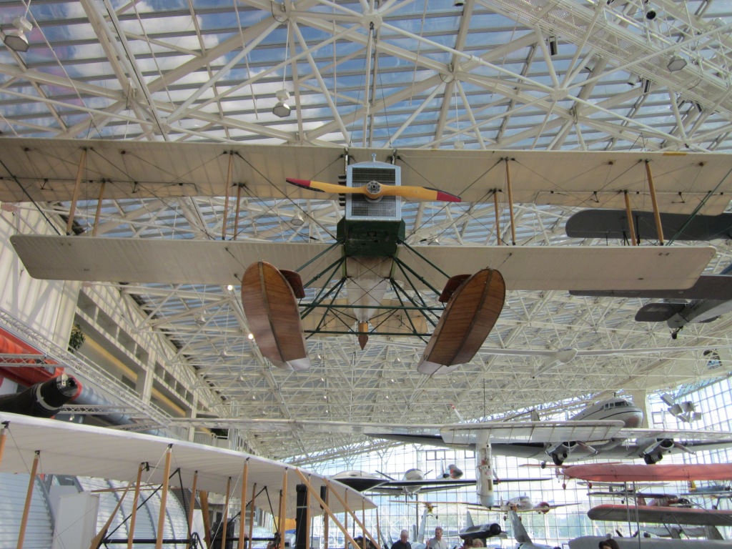
    • a replica of Boeing Model 1 (first Boeing airplane),
    • a Lockheed SR-71 Blackbird plus a cockpit for visitors to enter in it,
    • a 737 converted into a theater with movies being played inside,
    • an exhibition of the bush pilots of Alaska and the development of air mail,
    • some flight simulators,
    • a DC-3, a Bell “Huey” UH-1H Iroquois, etc.
  • Bill & Moya Lear Gallery (Space Exhibit, named after the founder of Lear Jet Corporation): located at the side of the Great Gallery it has a diorama of the Apollo 17 landing site, with rover included, a replica of the International Space Station Destiny Research Laboratory, etc.
  • The Tower: with direct view over the runway.
  • William E. Boeing Red Barn (named after Boeing founder): in my point of view this is “the” highlight of the museum (allow yourself over an hour for this part alone). It explains both:
    • the birth of aviation: with models and panels explaining the contributions of many of the aviation pioneers (see this blog post in which I went through some of them), and,
    • the history of Boeing: from the moment in which the timber businessman, Bill Boeing founds the company, the first Boeing Model 1 (see replica in the picture above), the tools, materials and processes used at the time, how did the factory look, the great aircraft programmes which meant different breakthroughs for the company and the great engineers behind them…
  • Charles Simonyi Space Gallery (named after the Microsoft executive who became in 2007 the 5th space tourist and who in 2009 travelled to the International Space Station): which highlight is the Space Shuttle Trainer used to train Space Shuttle astronauts at Johnson Space Center in Houston.
  • Airpark: with the Boeing 747 “City of Everett” (first ever 747, first ever wide-body aircraft), a Boeing 707 Air Force One, a Concorde, a Lockheed Constellation…
  • J. Elroy McCaw WWI and WWII galleries (named after a broadcasting magnate): unfortunately I did not have time to properly visit these galleries before the closing of the museum… a reason to come back again.

See some of the pictures I took at the museum:

This slideshow requires JavaScript.

I definitely recommend to visit this museum if you happen to be in Seattle. It is located in the South of Seattle at Boeing Field / King County airport. I would suggest to take no less than 5 hours to visit the museum and to arrive before noon, otherwise there will be some parts that you will not be able to visit properly (as it happened to me with the WWI and WWII galleries).

2 Comments

Filed under Aerospace & Defence, Travelling

West of here

Some years ago, I watched a TED talk in which the case of the topic of how language influenced the way we think was discussed. In particular I remembered that it was given as an example how the Guugu Yimithirr people, Australian aborigines, had a very developed sense of orientation because in their language there were not such words as “left”, “right”, “in front of” or “behind”, but they have to give relative positions or directions with words like “North”, “South”, “East” and “West”. That example was kept deep in my mind.

I would comfortably reckon myself as someone who has a good sense of orientation, and when visiting Seattle about 2 months ago I was quickly reminded of the example described above when seeing this kind of signs:

"Parking prohibited West of here".

“Parking prohibited West of here”.

We saw several of such signs, either giving instructions in relation to North/South or East/West. As in Seattle you have the Ocean coast mainly at the West, I would say that is easy for everyone to interprete these signs, but then again, not using that kind of language priming in English, I guess that some people will be mistaken from time to time.

P.S.: In the picture above, I knew where the West was and where my car was, I just won’t tell…

Leave a comment

Filed under Travelling

Manzanar War Relocation Center

During our honeymoon, on the way back from visiting Edwards AF Base, we decided on the spot not to take again highways 58 and 5 to San Francisco, but to go North by the Eastern part of Sierra Nevada and cross the whole of Yosemite National Park the following morning. With this new route we would drive more miles, give away a hotel reservation in Fresno but we were able to see the Red Rock Canyon State Park (famous for scenic rocky formations, featured in several films), Mount Whitney (with 4,421m the highest point of the Lower 48), Mono Lake (a terminal lake famous for its alkaline water) and Manzanar…

Manzanar War Relocation Center

Manzanar is the site where one of the concentration camps where thousands of Japanese and Americans with a Japanese origin were imprisoned during World War II. Manzanar is one black spot in the US history, let me quote from the Wikipedia:

Dr. James Hirabayashi, Professor Emeritus and former Dean of Ethnic Studies at San Francisco State University, wrote an article in 1994 in which he stated that he wonders why euphemistic terms used to describe camps such as Manzanar are still being used.

Let us review the main points of the debate. Over 120,000 residents of the U.S.A., two thirds of whom were American citizens, were incarcerated under armed guard. There were no crimes committed, no trials, and no convictions: the Japanese Americans were political incarcerees. To detain American citizens in a site under armed guard surely constitutes a “concentration camp.” But what were the terms used by the government officials who were involved in the process and who had to justify these actions? Raymond Okamura provides us with a detailed list of terms. Let’s consider three such euphemisms: “evacuation,” “relocation,” and “non-aliens.” Earthquake and flood victims are evacuated and relocated. The words refer to moving people in order to rescue and protect them from danger. The official government policy makers consistently used “evacuation” to refer to the forced removal of the Japanese Americans and the sites were called “relocation centers.” These are euphemisms (Webster: “the substitution of an inoffensive term for one considered offensively explicit”) as the terms do not imply forced removal nor incarceration in enclosures patrolled by armed guards. The masking was intentional.

I didn’t know about the imprisonment of Japanese Americans in American soil during the war until I came to Manzanar. During the same trip, we also had the chance to learn more about that topic in those times in Seattle at Pike Place Market, from where many Japanese Americans were first dispossessed from their shops and assets and then sent to concentration camps like Manzanar. 

After learning about this, I guess that the months after the bombing of Pearl Harbor (December 7, 1941) surely must have been very dramatic in the USA, and that political upheaval felt in DC must have been tremendous. Not only how to respond to that attack but to which extent were they safe in American soil, the suspicions or paranoia that people must have felt, the man haunts that must have happened, the incomprehension felt by those Americans…

On February 19, 1942, President Franklin D. Roosevelt signed Executive Order 9066, which authorized the Secretary of War to designate military commanders to prescribe military areas and to exclude “any or all persons” from such areas. The order also authorized the construction of what would later be called “relocation centers” by the War Relocation Authority (WRA) to house those who were to be excluded. This order resulted in the forced relocation of over 120,000 Japanese Americans, two-thirds of whom were native-born American citizens. 

Today is a National Historic Site that can be visited from dawn to sunset, on foot or by car, following a defined route which guides you through where the different parts of the camp were located, of which only a handful are standing or have been re-constructed.

This slideshow requires JavaScript.

See also some pictures from the other spots that I mentioned we saw during that day:

This slideshow requires JavaScript.

1 Comment

Filed under Travelling