Tag Archives: DR-400

Flight excursion to Menorca and Mallorca

Last weekend, with Luca and our children, we took one of the aeroclub’s DR-400 to make a flight excursion from Toulouse (France) to the islands of Menorca and Mallorca, in Spain. The excursion was part of a “Fly out” organised by the Aviation Society of the Airbus Staff Council in which 5 aircraft would make the same trip.

The main purpose of the flight was to visit Menorca, and we flew to Mallorca to refuel before coming back. It is an excursion that in the Society we had been trying to make since 2015 but we have had to cancel it due to bad or uncertain meteorological conditions several times. The flight includes a leap over the sea of about 1 hour from the East of Bagur (in Gerona) to the North of Menorca and, as there are no safe landing spots in that area, you want to have more or less certain good weather along the route both the day of the departure and return flights.

22. a Formentor, Alcudia, Cap Farrutx

Cape Formentor, Alcudia & Cape Farrutx.

We made 4 flights.

Toulouse Lasbordes (LFCL) – Perpignan (LFMP)

Flight duration: 1h11’.

Flight_route_LFCL_LFMP

We included this first stop over Perpignan just to refuel the aircraft to the maximum before flying over the sea all the way through Menorca, so in case of bad weather or any other problem at the destination we could make a comeback to France or somewhere else in the Spanish coast. We selected Perpignan instead of other viable options such as Ampuriabrava for various reasons, among them lower cost of fuel and landing fees.

In the way to Perpignan the sky was overcast (OVC) at a low level around Carcassonne, and, as I did not want to fly on top for that leg, this forced us to fly just at 1000 ft above ground and to follow the highway to Narbonne rather than taking a more direct route to Perpignan over the mountains. You can see the route we followed above.

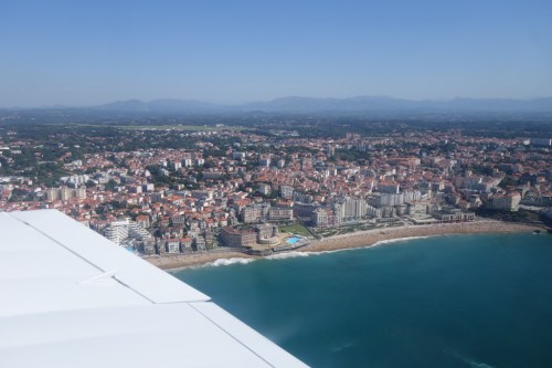
It was the first time I landed at Perpignan, but finding the field from the way points NL (in the coast) and NF was trivial. Once in the vicinity we integrated directly into the circuit for runway 31, closer to the fuel pump. There, we had a quick lunch and prepared for the following flight.

Perpignan_chart

Find the Garmin record of the flight here.

Perpignan (LFMP) – San Luis (LESL)

Flight duration: 1h56’.

Flight_route_LFMP_LESL

Just after the take-off from Perpignan we took a right turn towards the East and reached the coast South of waypoint EA. From then on we started climbing up to 5500 ft, the altitude selected for the flight over the sea (the highest, the better). In order to keep a high altitude you need to avoid the TMA from Barcelona, otherwise they may ask you to descend below 3000 ft. Thus, we went to the capes of Bear, then Creus and from then on South East heading to pass about 10 nm East of the VOR at Bagur. From then on we followed a series of IFR waypoints (NEMUM – AGENA – VERSO – TOSNU – SARGO).

TMA_BCN

Flying above the sea is not particularly eventful. You mainly need to maintain the altitude and attitude and the heading stable, as it is very easy to loose references with the difficulty to distinguish the horizon.

As far as radio communications are concerned: we were first transferred with the Gerona traffic control and then to the one of Barcelona. The communications were held in Spanish. Easy, as long as you have a flight plan and follow the announced route. Those frequencies were mainly used by commercial flights going to/from Barcelona or Palma, mainly Vueling flights. Also good to know is that as you fly away from Barcelona at some points you may not be heard by the control; no worries, keep going and sending the messages.

About an hour later we had in sight the North of the island of Menorca, the cape of Cavalleria. But before that, approaching the way point of SARGO (about 25 nm or 14 minutes from the shore) you need to descend down to below 2500 ft, though the control will ask to go down to 1000 ft AMSL as that is the limit of the air space class A around the main airport in Menorca, Mahon.

Cavalleria

Cape of Cavalleria.

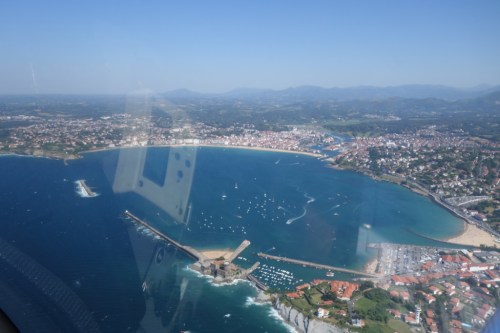
Once in sight of the shore we requested to follow the coastal line to the East down to the East Corridor for Mahon in order to reach San Luis from the East (the control had however proposed to surround the island around the West and South).

San Luis_chart

Following that route we took the opportunity to take some nice pictures of the coast, the lighthouses and the fortress of Isabel II at La Mola.

San Luis is a non-controlled aerodrome without radio. Therefore, you must stay connected to the frequency of Mahon and land at your discretion, with a circuit to the East of the runway (02/20). The aerodrome is managed by the Aero-club of Menorca. In their site you may find contacts and charts (old ones being in use). There are not official fees but a contribution is expected; 10 euros for landing, 5 for parking. These are paid at the restaurant by the apron, which serves very decent menus and where the staff will be happy to help you calling for  taxi.

We spent the remaining of Friday afternoon and all Saturday enjoying the beach and the hotel’s pools, including a beer on Saturday night with the colleagues from the Society at a bar by the beach, Es Corb Mari (in Son Bou).

Find the Garmin record of the flight here.

San Luis (LESL) – Son Bonet (LESB)

Flight duration: 1h10’.

Flight_route_LESL_LESB

As the aerodrome of San Luis doesn’t have a fuel pump we could refuel at the main airport of Mahon, but as it requires to contract handling (with expensive fees) we preferred to fly down to Son Bonet (in Mallorca island), which landing fee is less than 7 euros, no handling contracting is required and there is free parking for a stay below 2 hours.

We filed the flight plan on the phone with Menorca airport (at this time the number for flight plans being: +34971157138). On ground, we were already connected to the frequency of Menorca and right after take-off we were cleared to turn West and cross the axis of the airport in our way to the West corridor which took us to the South coast of the island up to the cape and lighthouse of Artrutx.

From Artrutx we flew over the sea towards the bay of Pollensa (making use of its VOR), in Mallorca, and then we flew within the inner side of the island following the road from Alcudia to Mallorca by way of Inca. When leaving Inca we passed with the frequency of Son Bonet (123.5) around which English is mainly spoken as there are quite a few helicopters flying in and out. Finding the aerodrome coming from the road was trivial and we easily integrated into the circuit for runway 23.

At Son Bonet we paid the landing fees (~ 7 euro) and filed the flight plan at the small office by the parking. We refuelled (~3.05 euros per litre of Avgas 100LL) and had some lunch before the long  flight to Toulouse.

Find the Garmin record of the flight here.

Son Bonet (LESB) – Toulouse Lasbordes (LFCL)

Flight duration: 3h04’.

Flight_route_LESB_LFCL

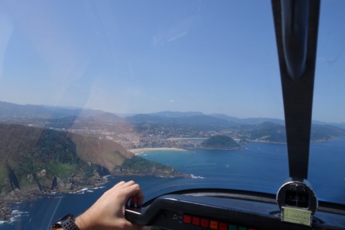
Once we were ready at Son Bonet, we got on board and departed from runway 23 again, took a right turn to the West during the climb to fly North of Son Moix on the way to Esporles to reach the coast of Tramuntana in order to fly along it up to the cape of Formentor.

Flight_route_LESB_LFCL_2

In the past, we had visited several spots along the way of this coast on the ground. The landscapes are remarkable. This time we wanted to get a view of them from the plane, which was breath-taking.

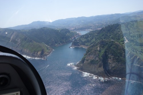
Once we reached Formentor we took a heading to the North and followed another series of IFR waypoints (KENAS – SULID – AGENA – NEMUM) to reach the East of the above mentioned VOR of Bagur, cape of Creus and enter back into French air space. This time, as the weather was clearer than during the first flight of the excursion, we maintained 5500 ft altitude until we had exited the TMA of Carcassonne.

Find the Garmin record of the flight here.

Some general remarks:

All the navigation logs were again prepared using the tool Mach 7, and during the flight we used the help of the AirNav Pro on the mobile phone (no tablet, though it would be easier). For Spain we had 1/1.000.000 chart from AIR MILLION (Editerra) and the 1/500.000 from Rogers Data. Neither of them has the IFR waypoints marked on them, so you need to write them down yourself in advance.

VFR aerodrome charts in Spain are retrieved from the site of ENAIRE, which in my opinion is less user friendly than the French equivalent. The charts themselves are comprised of too many different documents to handle; it is better to have a simple single PDF of 2-8 pages s in the French case for VFR. On top of that, not all small aerodromes have the information in ENAIRE, try googling about them or contact the local club.

1 Comment

Filed under Aerospace & Defence, Travelling

Flight excursion to the Flying Legends airshow at Duxford.

Two weeks ago, Albert, a work colleague, and I took one of the aeroclub’s DR-400 airplanes to make a flight excursion from Toulouse to Northampton Sywell, Old Warden and Duxford (England) as part of a “Fly out” organised by the Aviation Society of the Airbus Staff Council, in which 6 aircraft would make the trip.

The main purpose of the flight was twofold:

  • Visit the Shuttleworth collection and their evening flight display on Saturday 14th July.
  • Visit the Flying Legends airshow at Duxford, hosted at the Imperial War Museum, on Sunday 15th July.
Mont Saint 34_Michel

Mont Saint Michel.

During the trip we were to make 6 flights: Toulouse Lasbordes (LFCL) – Cherbourg (LFRC), Cherbourg – Sywell (EGBK), Sywell – Old Warden (EGTH), Old Warden – Fowlmere (EGMA), Fowlmere – Laval (LFOV), Laval – Toulouse Lasbordes. In all about 14 hours of flight time, which we split among the two of us, together with sharing the navigation and radio communications workload.

Flights_picture

We prepared the flights using Mach 7 online tool, with which we generated the flight logs and routes for GPS, which could only be charged onto Albert’s smartphone, I replicated them in my Air Navigator app on my phone as well, however we did most of the navigation by way of following the paper charts.

Chart

Having to fly most of France from South to North, we decided to overfly some castles of the Loire Valley (Chenonceau, Cheverny and Chambord), the racing circuit of Le Mans and Omaha beach in Normandy (which we couldn’t see well due to the presence of clouds at the time we passed). See below some of the pictures we took of those places (with the smartphone, no pro cameras on board).

1_Chenonceau

Château de Chenonceau.

2_Cheverny

Château de Cheverny.

3_Chambord

Château de Chambord.

4_Le Mans

Racing circuit of Le Mans.

We then made a stop, refuelled the airplane, ate some energy bars and departed for England. The weather seemed uncertain and there were several air traffic restrictions due to the Royal International Air Tattoo going on at Fairford, preparations for Farnborough air show, and the visit of Donald Trump, staying at Buckinghamshire. However, our colleague found a corridor through which we could fly smoothly past 15 h local time. We over flew the English Channel (La Manche) and approached the islands by first flying over the Isle of Wight (where I stayed one month during the summer of 1999 working at Camp Beaumont in Bembridge, at the eastern corner of the island, pictured below), the Hayling island leaving Portsmouth to our left, then up North by way of Winchester, Reading, Oxford and then Northampton. But as you can imagine, as there are not sign posts in the sky we were flying following the instruments and different navigation references close to those places. We took the opportunity to over fly Silverstone racing circuit.

5_Isle of Wight

Isle of Wight.

6_Silverstone

Silverstone racing circuit.

We then landed at Sywell, where we stayed for a night at the Aviators hotel, by the aerodrome, an ideal place to make an overnight stop.


The following morning we made a short flight to Old Warden, a small grass aerodrome where the Shuttleworth collection is based.

I found about the Shuttleworth collection some years ago in Twitter and started following their account (@Shuttleworth_OW). They happen to have arguably the largest collection of flying aircraft from the 1910s and 1920s. They do have the oldest flying machine in airworthy condition, a Bleriot XI from 1909. Rather than introducing the collection with a few paragraphs, I share here this video from their site:

For me, visiting the collection was a dream come true, moreover on a day in which they would fly most of their airplanes. See below a few pictures.

10_Bleriot XI

1909 Bleriot XI. The original oldest airplane in airworthy condition.

11_Triplanes

1920s biplanes (DX60X Moth, Southern Martlet).

12_Bristol Boxkite

Bristol Boxkite 1910 replica flying.

9_Avro Triplane

Avro Triplane 1910 replica.

I wanted to share a short video I took of the Bristol Boxkite 1910 replica flying just after taking off (a replica built in 1965). It took its time to gain some altitude, always at quite low speeds. It never went much higher than 50 ft. It was wonderful to see it flying.

We stayed the night over at the camping by the aerodrome and in the morning we departed for Fowlmere, another grass aerodrome a few miles from Duxford. The taxiway at Fowlmere was fully packed of small airplanes (including the Antonov An-2 coming from Germany that you can see below) and tents of pilots that had been camping the previous night or would camp the following one, as we did.


We got a faboulous breakfast at the airfield and then drove to Duxford to attend the Flying Legends air show and visit the Imperial War Museum.

Flying-Legends-2018Our Fly out was organised by a fellow British colleague, Derek. He recalled how being brought to Flying Legends as a child by his father had been a marking moment. He only came again decades later. The air show is one of the biggest and best classic aviation events in the world. If you have the chance to visit it once, do not hesitate, go.

This year the show commemorated the 100th anniversary of the Royal Air Force and the 50th anniversary of the filming of Battle of Britain which had Duxford as one of the locations and some of those very airplanes as main characters of the movie. Other locations of the filming were the Tablada airfield in Seville (where Airbus Defence has facilities), the coast in Huelva passed as Dunkirk or San Sebastian as if it was Berlin.

There are plenty of aircraft to see up close, from the flight line, many exhibitors come with  books, models, clothing, memorabilia, etc., you’ve got the museum in itself (!) to visit, you have literally dozens of WWII birds flying, among them: Supermarine Spitfire (we saw a formation of 11 of them flying), Hawker Hurricane, North American P-51 Mustang and resident Boeing B-17 Flying Fortress Sally B (only B-17 in flight in Europe)… By the end of the day you will be more than overwhelmed, exhausted, but with that smile of wonder when watching those jewels fly up in the air while you hear the engines roaring, the music and the explanations from the commentator of the show.

21_Flying Fortress

Boeing B-17 Flying Fortress Sally B.

20_Flying Fortress

Boeing B-17 Flying Fortress Sally B.


See this short video of the Balbo formation flight at the end of the display with 25 single engine WWII birds flying…

After the show we headed back to Fowlmere where we had dinner with three other colleagues (French and German) before walking to the airfield to camp by our airplane, which felt as the aviation of the beginning of the XX century.

22_camping

Fowlmere_4

Monday 16th July, feeling exhausted and overwhelmed, was the day to come back to Toulouse. The weather seemed good in England and to cross the channel but not so in France, so we took it with calm. We flew through the East of London, crossed the channel and then overflew all the coast of Normandy down to Omaha beach, then we headed South West to the Mont Saint Michel and then to the airport of Laval. There we rested for a couple of hours, ate more energy bars, studied the meteorological conditions to go further South and finally departed back to Toulouse Lasbordes.

24_London

London skyline.

25_Qeen E II bridge & Littlebrook Power Station

Queen Elizabeth II bridge and Littlebrook Power Station.

26_Thames

Thames river estuary.

27_Cliffs d'Etretat

Cliffs of Étretat, Normandy (France).

28_Le Havre Pont de Normandie

Le Havre. Pont de Normandie.

29_Oil tankers

Oil tanker ships departing from Le Havre.

30_Sword beach

Sword beach (British). Normandy Landing.

31_Arromanches

Remainings of Arromanches mulberry bridge.

32_American cemetery Omaha

American cemetery at Omaha beach.

33_Omaha beach

Omaha beach.

Mont Saint 34_Michel

Mont Saint Michel.

Main takeaways and afterthoughts:

  • The airshows and visits were totally worth it. Dreams come true.
  • Over flying those castles, circuits, beaches, historical landscapes… you can imagine, breathtaking.
  • Radio communications: much easier than expected, in England as well (even if the there were lots of radio frequency changes to be made around London). French in France, English in England.
  • We made ourselves follow in each air space. It forces you to interact more with the control but it adds to the safety of flight (traffic information overflying Saint Michel or the castles is advice-able).
  • Flight plans: in France they are not required for the long flights we did South-North flying spaces E and G. But we filed them. It allows the control to better follow you. They know your plans, they give clearances for D spaces without hesitation.
  • All the terrains we visited in England required PPRs (a colleague took care of this).
  • To fly into England a GAR report must be submitted in advance.
  • We didn’t touch a single sterling pound in the four days, credit cards almost did the trick for everything. A colleague had to pay for a taxi and a meal. We could have avoided that by selecting alternatives which accepted credit card payment.
  • We had to divert due to the meteorological conditions when arriving to one of the destinations. Clouds and fog were closing our visibility. We found ourselves with no more than 3-4 km of visibility and flying very low, so we turned back. The two diversion aerodromes we had initially selected would not do the trick (in the middle of the cloud region). We had to look for a third one in flight. That was stressful. Luckily we were two pilots on board: one keeping the airplane on air, the other navigating, looking for a suitable aerodrome and downloading the aerodrome chart (we carried about 30 on board, but not the one we finally needed). Lessons learnt: never spare charts, you may need them; ensure you’ve got batteries and chargers on board (you may need them in the worst situation), if you are the only pilot on board, but have passengers with you, try to get one of them briefed in advance of what can he or she do if something happens.

After this excursion I have completed just above 120 flight hours, and I am quite happy with the flight training provided by the aeroclub and system in France. Before the excursion we had some uncertainties about some aspects of the flight. In the end all of it was much easier than expected.


2 Comments

Filed under Aerospace & Defence

Flight excursion to San Sebastian

One of the goals that I had for this year as a recently qualified private pilot was to make a flight crossing the French border. For this purpose, last July I approached a colleague, Asier, who had obtained his license years ago and already had the experience of having flown to San Sebastian, the destination chosen for the flight.

We took a day off at the office to have time enough to make the return flight on a day and avoid constraints with the availability of airplanes. The weather was very good early in the morning all the way from Toulouse to San Sebastian, with only some wind, and a few gusts by the coast.

On the way to San Sebastian we would make a short stop over by Pau. On the way back we had planned another one by Tarbes, but in the end we skipped it. The outgoing flight took us 2h28′ (engine running time, including the stop over) for over 176 nautical miles; the return one, 2h04′.

The navigation went rather well even if we didn’t make use of the GPS and just navigated using the charts, compass and VOR… It basically consisted in departing from Toulouse Lasbordes and flying around the CTR of Toulouse via the southern itinerary. Once arrived at the SN way point we took a west heading towards the VOR of Tarbes (TBO) and from there we sought the integration in the CTR of Pau. At Pau we simply went to the general aviation parking, drank some water, refreshed ourselves, rearranged some papers, visualized the second part of the flight and got ready for departure. While at the holding point we had to wait for an airliner and a French Air Force CN-235, a nice view considering that both Asier and I used to work for Airbus Military.

chart-route-ss

Navigation log.

Navigation log.

It was when flying around Pau that we noticed that the temperature of the oil was rather high, almost in the red zone of the arc. As the pressure was OK we decided to simply reduce the rpm. The action was succesful in lowering the oil temperature back to the green area of the arc, but we were forced to fly for the rest of a very hot day at a somewhat slower speed (between 150-170 km/h vs. the planned 180-200).

Final approach at Pau airport.

Final approach at Pau airport.

From Pau we followed the transit towards Biarritz via Orthez and Dax that follows more or less the high speed way and river Gave de Pau. We flew around Biarritz by the North and coastal transits. The bay and beach of Biarritz are wonderful on the ground, even more so from the air. In general it is a very recommendable experience to fly from Biarritz to San Sebastian, as despite of the turbulence that you may encounter the views are breathtaking. See the pictures and video below.

Atlantic coast.

Atlantic coast.

Biarritz

Biarritz

St Jean de Luz

St Jean de Luz

Leaving St Jean de Luz,the French air traffic controller bid us farewell in Spanish. Those were the first words in Spanish I ever exchanged in the radio as I obtained my license in France and the FCL055 to be qualified to speak in English when flying abroad, but I had never flown by myself to Spain. We then contacted the air traffic control at San Sebastian, who were waiting for us. While talking to the controller I felt very awkward, as despite of being a native Spanish and having reviewed aviation phraseology in Spanish the previous days, the terms and sentences didn’t come natural. I am sure that I used plenty of expressions that are either not correct or not in use. I noticed a couple of them by myself (“back track” the runway was employed by the controller in English, rather than a Spanish form I used or “Responde” for the transponder); there ought to be many more.

Air space around San Sebastian was very quiet. We demanded a clearance to make a detour by the bay of San Sebastian and come back to the airport in neighboring Fuenterrabia and it was granted without hesitation. Basically we could do as we pleased, we just needed to report when approaching the airport. After taking some pictures of the bay we headed back to the airport and we flew through the port of Pasajes, which I had visited on ground a few months before.

San Sebastian

San Sebastian

San Sebastian

San Sebastian

Entering Pasajes.

Entering Pasajes.

It took me a while to spot the runway in long final but the landing went smoothly.

Final approach to San Sebastian airport Fuenterrabia.

Final approach to San Sebastian airport at Fuenterrabia.

We then went to have lunch with a relative of Asier at a close by restaurant and later had a walk through the village centre (Fuenterrabia).

dsc_0130

About 3 hours later we came back to the airport. Just in time to take-off and leave before the weather deteriorated. Clouds were approaching the airport from Pasajes, thus we took off heading North (runway 04), with heavy cross wind (310 degrees, 15-20 kt) in what was the most difficult take-off I have experienced so far. Once on air, at Biarritz the controller adviced us (and any other aircraft around) to either land or fly inland as soon as possible as a front was approaching from the sea. So we did, turned east, inland, and continued our flight towards Toulouse.

Biarritz

Biarritz

The rest of the flight went very smoothly, even though we skipped flying over Tarbes after having slightly diverted from our planned route as demanded by controllers.

To conclude this post, find below:

  • a video we made during the flight. Despite having played with the camera for most of the flights, of having collected over 1 hour of footage, most of it is about flying in the countryside, not that interesting to watch. However, I rescued the approach and landing at Pau and the flying along the coast in the way back, which are worth seeing (~10′).
  • the navigation log as it was after using it during the flight.

Used navigation log.

Used navigation log.

If you liked this post, find in the page Flight excursions of this same blog, a list of posts describing similar experiences to other destinations.

1 Comment

Filed under Aerospace & Defence

Flight excursion to Rocamadour and Saint Cirq Lapopie, via Montech and Moissac

Rocamadour is a small village built in the gorges of a tributary to the Dordogne river. Several of its houses, churches and shops are partially built within the rocks. With about 500 inhabitants it receives 1.5 million of visitors per year, making it one of the most visited places in France and a major attraction for pilgrims, who among other things come to see a black Madonna in a chapel in the rock carved by Saint Amadour, hence the name of the village.

On the way to Rocamdour, flying from Toulouse there is Saint Cirq Lapopie, a small village built on a cliff over the river Lot. Both Rocamadour and Saint Cirq Lapopie are two of the most beautiful villages in the Midi-Pyrénées region and an obvious destination for an excursion, on the ground (which we did years ago) and flying.

Last Saturday, my father in-law and I booked a plane (a DR-400-120) at about 14:10 to fly over those places. In the way we would fly over Montech, to see the “Pente d’eau” from the sky (1), and Moissac, to see the Pont-Canal du Cacor, a bridge over the river Tarn made to allow the canal Lateral (an extension to the canal du Midi) to continue its course towards Bordeaux.

The flight would be over 175 nautical miles (over 320 km) and would last almost 2 hours with the integration to the aerodrome circuit, though in the end we spent 2 hours and 10 minutes with the rounds we made around the different spots. The navigation went rather well with no other help than the chart, compass, heading indicator and VOR (no GPS nor tablets). We had some doubts at a couple of points but we quickly found ourselves, once with the help of the controller.

Navigation log.

Navigation log.

This was the first flight in which we used the GoPRO video camera that I got last Christmas together with the suction pad to stick it to the windshield. With it we were able to have over 90 minutes of videos recorded that I have tried to shorten into the following 7 minutes:

At some points in the video the ground below seems to move slowly: we were flying at between 180 and 200 kilometres per hour, but at some 1,500 to 2,000 feet (500-700 m) above ground that is the way it feels. Be assured that the closer you get to the ground the faster it feels :-).

In the chart below you can see the route we followed: departure from Toulouse-Lasbordes (East of Toulouse), waypoint EN, Labastide-St. Pierre, Montech (South West of Montauban), Moissac (West of Castelsarrasin aerodrome), St.Cirq Lapopie (via Cahors) and Rocamadour (North West of Figeac).

Chart

Lastly, some pictures with the images of both villages and the flight log as used after the flight.

St Cirq Lapopie.

St Cirq Lapopie.

Rocamadour.

Rocamadour.

Rocamadour.

Rocamadour.

Navigation log as used after the flight.

Navigation log as used after the flight.

(1) See here a post I wrote about it.

(2) Actual engine running time: LFCL-LFCL: 2.17 FH (2h10′, with the aircraft registered as F-GORM, with an engine powered with 120 HP) (taking off and landing from runway 15).

1 Comment

Filed under Aerospace & Defence, France, Travelling